Building on more than 30 years of scientific studies, NOAA issued a notice of proposed rulemaking (proposed rule) to expand Flower Garden Banks National Marine Sanctuary in May 2020. The proposal would expand the sanctuary from 56 square miles to 160 square miles to protect additional critical habitat in the Gulf of Mexico.
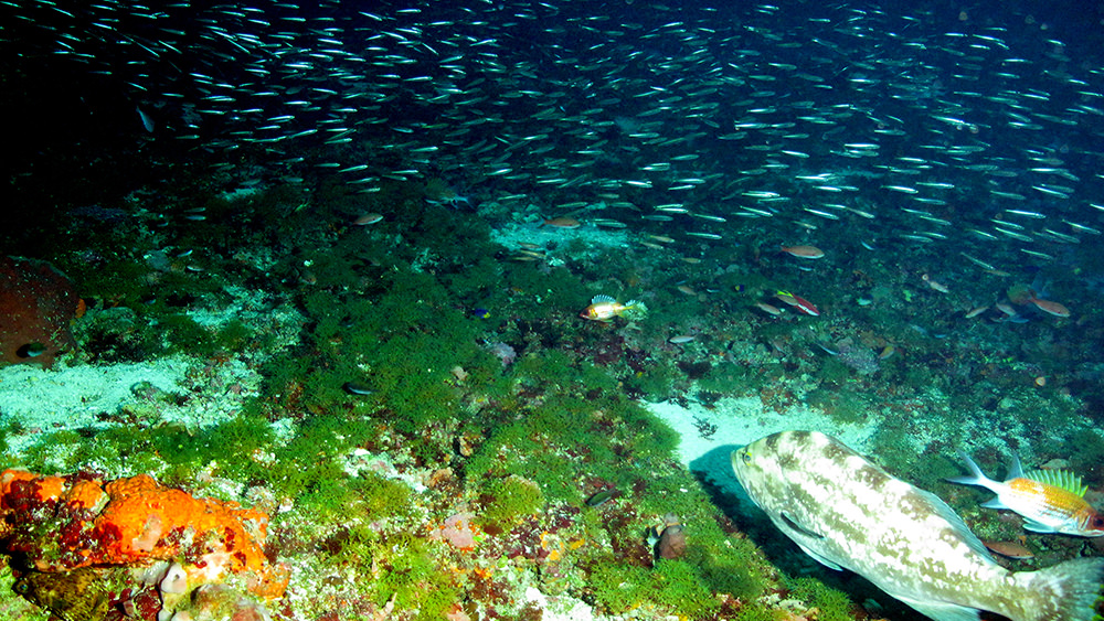
The highly productive marine ecosystems in the proposed expansion areas support a variety of fish and invertebrate communities of biological and economic importance. Photo: NOAA/UNCW-UVP
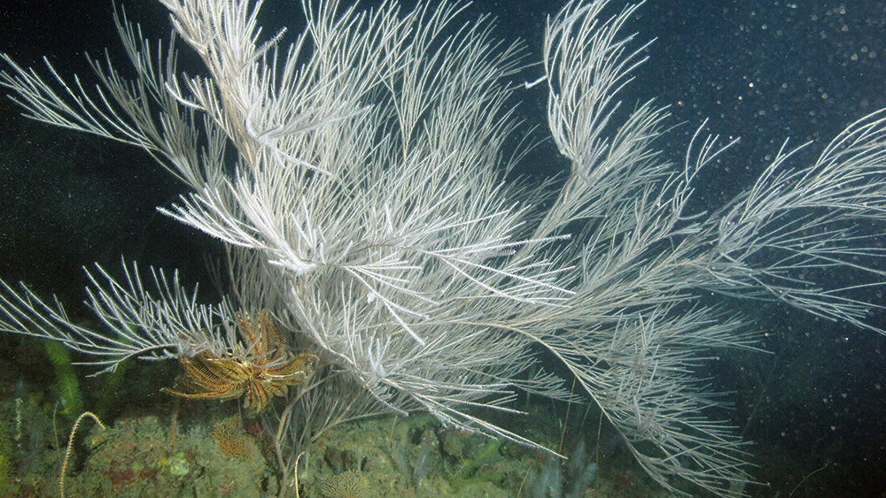
Large black corals are found throughout deep reef habitats of the northwestern Gulf of Mexico. Photo: NOAA/UNCW-UVP
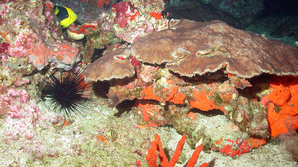
Unique coral reefs in some areas of McGrail Bank are dominated by large colonies of blushing star coral (Stephanocoenia intersepta). Photo: NOAA/UNCW-UVP
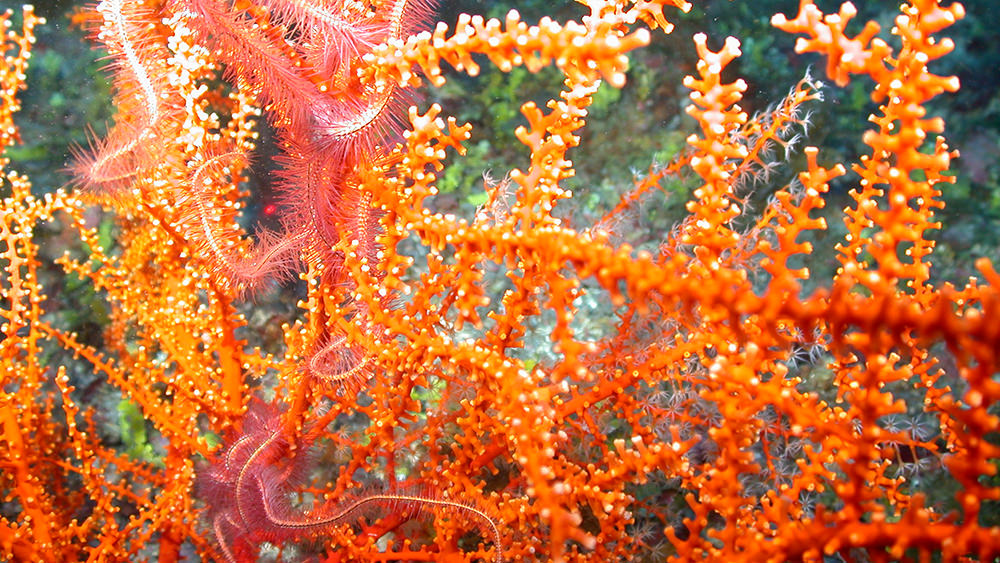
Colorful deep corals provide important habitat for other organisms throughout the northwestern Gulf of Mexico. Photo: NOAA/UNCW-UVP
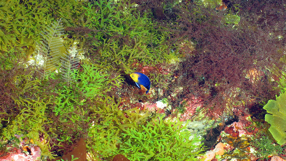
Shallow reef species, like this beautiful cherubfish at Parker Bank, also make use of mesophotic habitats throughout the proposed expansion areas. Photo: NOAA/UNCW-UVP
The existing Flower Garden Banks National Marine Sanctuary was designated in 1992 and added to in 1996. It includes the northernmost coral reefs in the continental United States, deepwater reef communities, and other essential habitats for a variety of marine species.
The proposed rule covered the addition of 14 other reefs and banks to the sanctuary. These reefs provide important habitat for recreationally and commercially important fish, as well as threatened or endangered species of manta rays, sea turtles, and corals.
Also included in the proposed rule was the extension of existing sanctuary protections to the new areas to limit the destructive impact of activities related to fishing with bottom-tending gear, ship anchoring, oil and gas exploration and production, and salvage activities on sensitive biological resources.
COMMENTS REQUESTED
NOAA invited the public to provide input on any aspect of the notice of proposed rulemaking during a public comment period from May 1 through July 3, 2020. The agency also requested specific input on the following three items:
Changes to the Proposed Boundaries in the Revised Preferred Alternative
Based on the Sanctuary Advisory Council recommendations in response to the DEIS, NOAA has made a number of changes to the boundaries of the polygons surrounding the banks and submerged features. NOAA is soliciting public comment on the revised boundaries.
Pelagic Longline Exemption Request
Existing protections for FGBNMS include a prohibition on the possession and use of fishing gear with the exception of conventional hook and line gear. Pelagic longline gear is used to target yellowfin tuna and swordfish in the Gulf of Mexico, including in the proposed sanctuary expansion areas. NOAA's National Marine Fisheries Service, Atlantic Highly Migratory Species Management Division, has submitted a request for an exemption for pelagic longline gear to be added to the current exemption for conventional hook and line gear in the sanctuary. NOAA is soliciting public input on this request.
Spearfishing Exemption Request
Existing protections for FGBNMS include a prohibition on the possession and use of spearfishing equipment. During the public comment period for the DEIS, NOAA received several requests for an exemption to this prohibition for new expansion areas. Additionally, the Sanctuary Advisory Council's 2018 recommendation for sanctuary expansion also included a recommendation to allow free-diving spearfishing at all new banks, but not within the 3 banks of the existing sanctuary. Additionally, the SAC requested an exemption for the possession of spearguns (stowed and not available for immediate use) on board a vessel within the boundaries of the current FGBNMS, but the vessel may not be in possession of any reef fish species (with the exception of bait fish). Finally, the GMFMC also recommended that NOAA consider an exemption for the possession and use of spearfishing equipment in the sanctuary. NOAA is soliciting public input on this request.
Comments Submitted
There were three ways to submit comments on the proposed rule: online via www.regulations.gov, by mail to the Sanctuary Superintendent, or in person during any of three virtual public meetings.
During the public meetings, comments were limited to three (3) minutes per person. If participants could not get their audio to work during the meetings, they were instructed to email their comments to fgbexpansion@noaa.gov and their comments were read out loud by one of the webinar organizers.
Although the public comment period has closed, all of the submitted comments may still be viewed at www.regulations.gov under docket number NOAA-NOS-2019-0033.
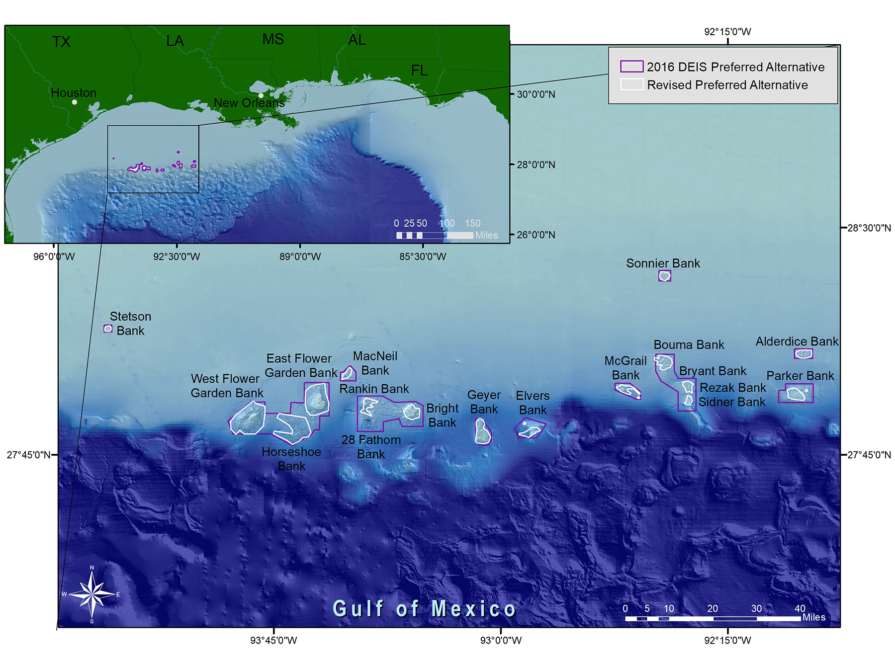
WHAT CHANGED SINCE THE 2016 DEIS?
On June 20, 2016, NOAA released a draft environmental impact statement (DEIS) including a set of alternatives that would implement potential changes to the sanctuary. The preferred alternative from the DEIS would have added 15 banks to the sanctuary (for a total of 18 banks) and resulted in an increase of the sanctuary area from 56 square miles to approximately 383 square miles.
After a lengthy process and significant input from primary constituents, the Sanctuary Advisory Council developed a revised recommendation. This, along with public comments, industry input, and interagency consultations (with NOAA Fisheries, Gulf of Mexico Fishery Management Council, the Bureau of Ocean Energy Management, the U.S. Coastguard, and the U.S. Navy), resulted in what became NOAA's revised preferred alternative for sanctuary expansion. The notice of proposed rulemaking was based upon this revised preferred alternative.The proposal would add 14 banks (for a total of 17 banks) and increase the sanctuary size to approximately 160 square miles.
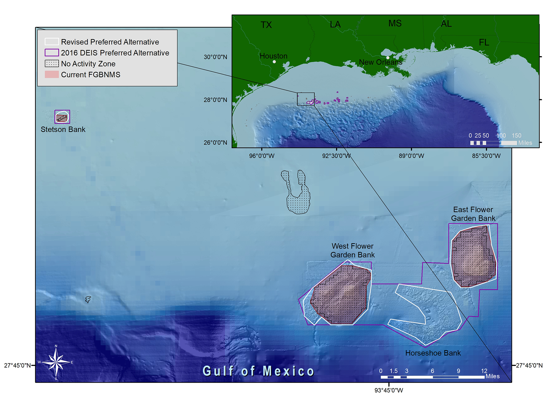
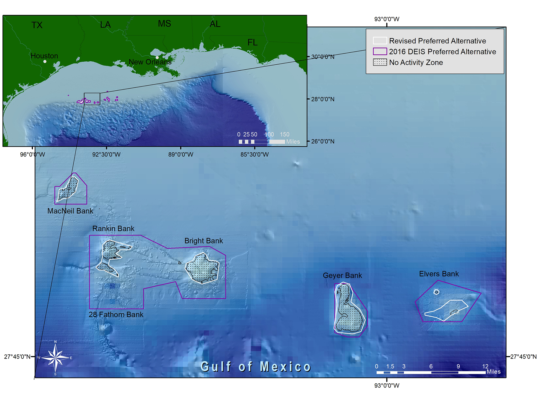
NOAA reduced the size of the expansion areas proposed in the 2016 DEIS preferred alternative to minimize user conflicts and potential economic impacts to the offshore energy industry. As a result, many of the proposed boundaries are closely aligned to pre-existing No Activity Zones established by the Bureau of Ocean Energy Management, the agency that regulates oil and gas exploration and production activities.
| Proposed Expansion Areas | 2016 DEIS Preferred Alternative (sq. miles) | 2020 Revised Preferred Alternative (sq. miles) |
|---|---|---|
| East Flower Garden/West Flower Garden/Horseshoe Banks | 147.4 (multi-bank complex) | 93.7 (East 27.8, West 37.2, Horseshoe 28.7) |
| Bouma/Bryant/Rezak/Sidner Banks | 53.6 (multi-bank complex) | 13.4 (Bouma 7.7, Rezak 3.7, Sidner 2.0) |
| Rankin/28 Fathom/Bright Banks | 82.9 (multi-bank complex) | 13.3 (Rankin/28 Fathom 5.6, Bright 7.7) |
| Alderdice Bank | 8.0 | 5.0 |
| Elvers Bank | 20.1 | 4.6 |
| Geyer Bank | 15.3 | 11.5 |
| MacNeil Bank | 8.3 | 2.7 |
| McGrail Bank | 12.0 | 4.7 |
| Parker Bank | 27.7 | 7.0 |
| Sonnier Bank | 5.6 | 3.1 |
| Stetson Bank | 2.3 | 1.4 |
| TOTAL | 383.2 | 160.4 |
REVISED PREFERRED ALTERNATIVE
During development of the proposed rule, sanctuary staff worked closely with constituents, particularly those within the oil and gas and fishing industries. The Bureau of Ocean Energy Management (BOEM) participated as a cooperating agency.
Below are a series of maps showing boundary comparisons between the 2016 DEIS preferred alternative and the 2020 revised preferred alternative specified in the notice of proposed rule.