Since Flower Garden Banks National Marine Sanctuary does not exist in isolation, it is important to understand the larger context of the surrounding Gulf ecosystem, including the currents, watershed, and geology.
Currents
From the south, the Gulf is fed by a current of warm water from the Caribbean, which enters the Gulf between Mexico's Yucatan Peninsula and Cuba. This forms the Gulf Loop Current, which flows north for a bit then makes a u-turn and heads south along Florida's west coast and exits through the Florida Straits.
The Loop Current is variable, sometimes barely entering the Gulf before turning, while at other times, it travels almost to Louisiana's coast before swinging toward Florida.
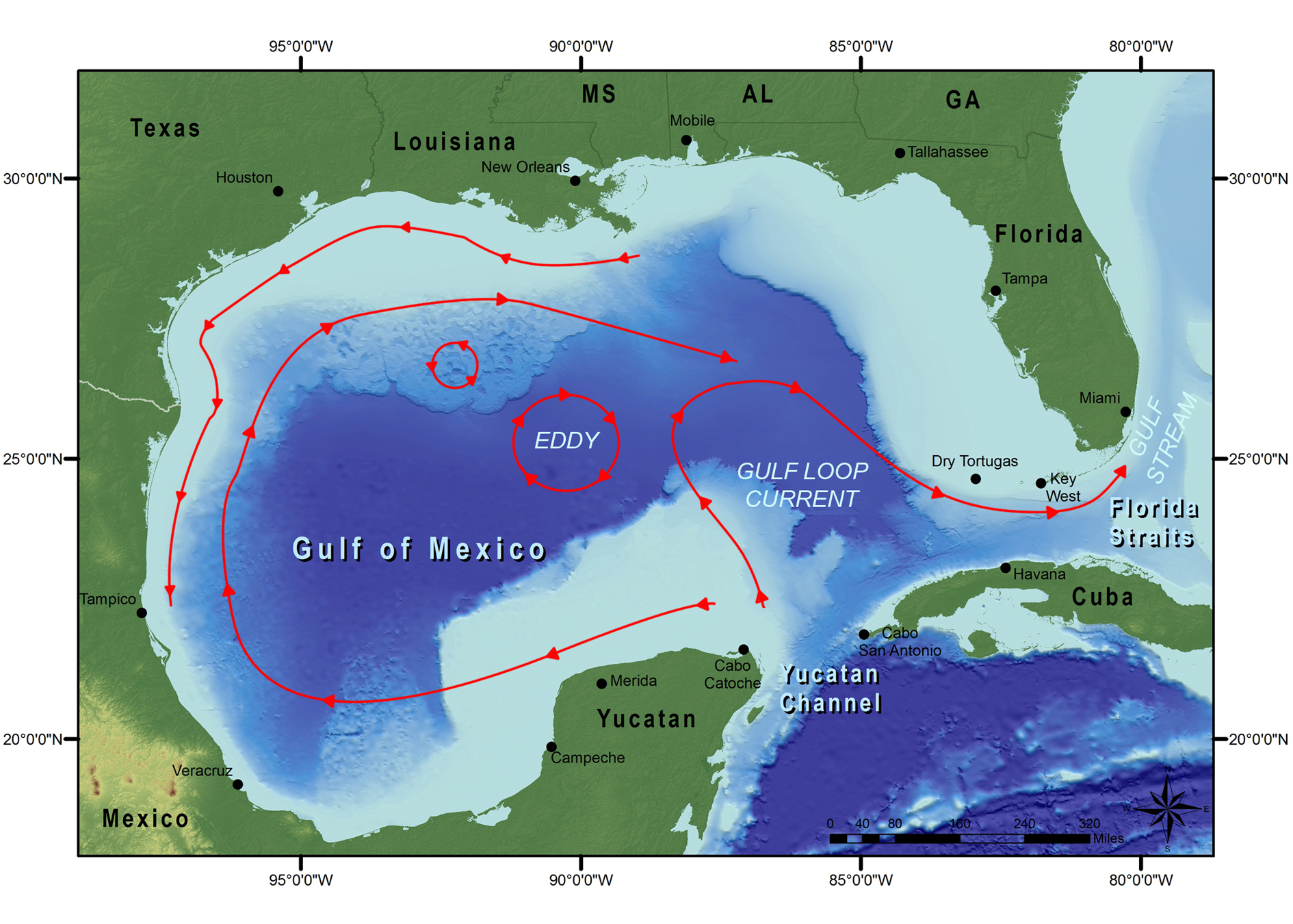
Portions of the loop often break away from the main current and form circular eddies that move westward, flowing past many of the sanctuary banks. These eddies of water bring animal larvae, plant spores, and other imports from the south, which probably accounts for most of the Caribbean species found in the northwestern Gulf.
Shallower, wind-driven currents also circulate in the Gulf. Some travel counter-clockwise close to the Louisiana, Texas, and Mexico coastlines. Other wind-driven currents travel further from the coastline in a clockwise direction, beginning near the Yucatan peninsula. These cross over the sanctuary banks from the opposite direction of the Gulf Loop eddies and add to the Caribbean influence in the region.
Based on these current patterns, the coral reefs off Mexico are the most likely source for the corals growing at the Flower Garden Banks and a few of the other shallower banks of the sanctuary.
Watershed
The watershed for the Gulf is huge! Two-thirds of the continental United States, all of eastern Mexico, and a small part of Canada drain into the Gulf. The Mississippi River Basin accounts for the single largest portion of this watershed. How people manage this watershed is very important to gulf health.
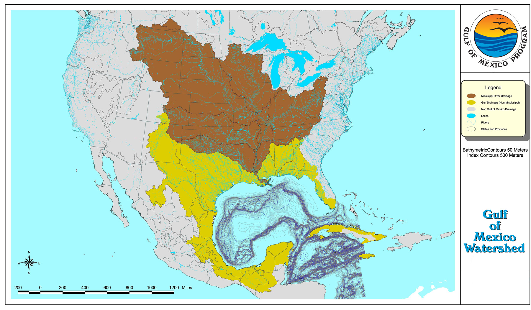
Rivers within this watershed bring with them all of the runoff accumulated from cities, suburbs, rural areas, and wildlands along their routes. This includes nutrients, sediments, and physical debris that may be harmful to our reef habitats.
Before these rivers reach the Gulf, a percentage of water is also removed for municipal, industrial, and agricultural use. This reduced freshwater outflow can negatively affect the health of coastal estuaries that provide nursery areas for many species that later move offshore.
Water quality is a vital component of healthy marine ecosystems. Please consider how you can make a difference.
Salt Domes
The underlying geology of Flower Garden Banks National Marine Sanctuary is salt domes. Without salt domes, we wouldn't have the raised mountains, ridges, troughs, and hard bottom patches that we call banks.
What is a salt dome? To understand, we have to go back in history about 190 million years when the Gulf was a very shallow sea. The hot dry climate at that time caused a lot of evaporation, depositing a thick layer of salt on the sea floor.
As the Gulf deepened and rivers began to flow from the land to the sea, mud, sand, and silt were steadily deposited over the salt layers. Eventually, pressures from these denser overlying sediments became great enough that the salt layers began to push upward. In some places the salt layers broke through completely, while in others they simply forced the seafloor to bulge upward in distinct domes.
Video animation of salt dome formation at East Flower Garden Bank (Video Description). Credit: Visual Candy/FGBNMS
The shape of the salt deposit, or salt diapir, is most often a cylindrical form about 1/2 to 2 miles across. Movement of this salt "plug" causes faults and cracks in the overlying and surrounding rock, allowing pathways for trapped oil and gas to travel and collect. This is what makes the banks hotspots for oil and gas exploration.
How close is the salt to the earth's surface (i.e. the sea floor)? That varies by location. At some sites the salt lies only a few feet beneath the sea floor sediments. In others, it may lie over 10,000 feet deep.
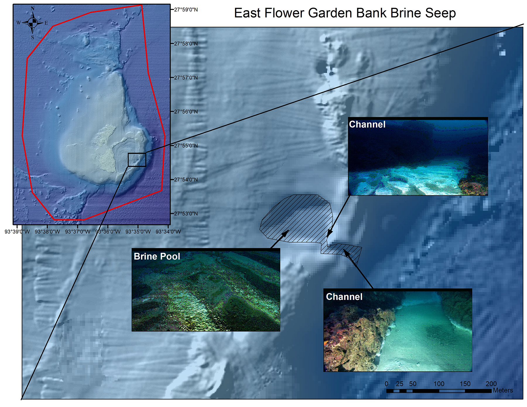
At East Flower Garden Bank, it is close enough to the the seafloor that we have a brine seep. At that location, about 240 feet deep (73 meters), super salty water (over 200 ppt) seeps out of the seafloor and settles into a pool up to 10 inches deep along the east flank of the bank.
Salt domes occur across the continental shelf of the northwestern Gulf and some even occur on land--High Island, TX and Avery Island, LA are two examples.
What is a Bank?
The term "bank" is part of our sanctuary name, but why is this geologic feature so important? Discover what makes a bank so special, and how banks feature prominently in three different national marine sanctuaries.
Fantastic Ocean Places you can Bank On
